
Sigiriya, Sri Lanka (Ceylon)
Sigiriya or Sinhagiri (English meaning of
the Sigiriya is 'Lion Rock') which is an ancient
rock fortress located in the Matale District nearby Dambulla in
the Central Province, Sri Lanka. It has the surface elevation by 265M (869Ft)
above the sea level.
According to the ancient Sri
Lankan chronicle “The Culavamsa”, this
site was selected by King Kashyapa (477
– 495 AD) for his new capital. He built his palace on the top of this rock and
decorated its sides with colorful frescoes. The whole face of the hill appears
to be like a gigantic picture gallery. The paintings would have covered most of
the western face of the rock where area is approximately 140M long & 40M
high. There are references in the graffiti to 500 ladies frescoes in these
paintings. However, most have been lost forever. On a small plateau about
halfway up the side of this rock, he built a gateway in the form of an enormous
lion. The name of this place is derived from this structure — 'Sinhagiriya', the Lion Rock.
The
capital and the royal palace were abandoned after the king's death. It was used
as a Buddhist monastery until the 14th century. Sigiriya today is a UNESCO
listed World Heritage Site. It is one of the best-preserved examples of ancient
urban planning in Sri Lanka (Ceylon).
History About Sigiriya
The environment around the Sigiriya may have been inhabited
since prehistoric times. There is clear evidence that many rock shelters and
caves in the vicinity were occupied by Buddhist monks and ascetics from early 3rd
century BC. The earliest evidence of human habitation at Sigiriya is the
Aligala rock shelter to the east of Sigiriya rock, indicating that the area was
occupied nearly five thousand years ago during the Mesolithic Period.
Some People believe Mythical King Ravana has erected Sigiriya
palace and he used it as his mansion. They even provided many pieces of
evidence in proving them.
Sigiriya Gardens Complex
The Gardens of the Sigiriya city are one of the most important
aspects of the site for the fact that it is among the oldest landscaped gardens
in the world. The gardens are divided into three distinct forms but in a linked
way : Water Gardens, Cave and Boulder Gardens and Terraced Gardens.
Ø Water Gardens
The water gardens can be seen in the central section of the
western precinct. Three principal gardens are found here. The first garden
consists of a plot surrounded by water. It is connected to the main precinct
using four causeways with gateways placed at the head of each causeway. This
garden was built according to an ancient garden form known as 'char
bagh' and is one of the oldest surviving models of this form. Further, it contains two long, deep pools set on either side of the path. Two shallow,
serpentine streams are leading to these pools. Fountains made of circular
limestone plates are placed here. Underground water conduit supply water to
these fountains which are still functioning especially during the rainy season.
Two large islands are located on either side of the second water garden. Summer
palaces are built on the flattened surfaces of these islands. Two more islands
are located farther to the north and the south. These islands are built in a
manner similar to the island in the first water garden. The third garden is
situated on a higher level than the other two. It contains a large, octagonal
pool with a raised podium on its northeast corner. The large brick and stone
wall of the citadel is on the eastern edge of this garden. The water gardens are
built symmetrically on an east-west axis. They are connected with the outer
moat on the west and the large artificial lake to the south of the Sigiriya
rock. All the pools are also interlinked using an underground conduit network
fed by the lake and connected to the moats. A miniature water garden is located
to the west of the first water garden consisting of several small pools and
watercourses. This recently discovered smaller garden appears to be built after
the Kashyapan period, possibly between the 10th and 13th centuries.
Ø Boulder Gardens
The Boulder Gardens consist of several large boulders linked by
winding pathways. The gardens extend from the northern slopes to the southern
slopes of the hills at the foot of Sigiris rock. Most of these boulders had a
building or pavilion upon them. There are cuttings that were used as footings
for brick walls and beams. They were used to be pushed off from the top to
attack enemies when they approached.
Ø Terraced Gardens
The Terraced Gardens are formed from the natural hill at the
base of the Sigiriya rock. A series of terraces rises from the pathways of the
boulder garden to the staircases on the rock. These have been created by the
construction of brick walls and are located in a roughly concentric plan around
the rock. The path through the terraced gardens is formed by a limestone
staircase. From this staircase, there is a covered path on the side of the
rock, leading to the uppermost terrace where the lion staircase is situated.
How to reach Sigiriya
Ø
By Train
It's
situated 168km (104mi) away from Colombo, Sri Lanka. Unfortunately, No railway
line is available to Sigiriya but if you wish you can travel by train. The
nearest Train station is Habarana which is 18km (11mi) away from Sigiriya rock
fortress. From the Habarana train station, you can catch a bus or hire a vehicle to
Sigiriya. If you choose to travel by train, it will take approximately 6 hours
to reach Sigiriya.
Ø By Road
From
Colombo, you can find two roads to reach Sigiriya, one is Colombo to Ambepussa
(A1 Road /Colombo - Kandy Main road) then turn left at Ambepussa clock tower
junction to take Ambepussa - Trincomalee Road (A6 Road) till Inamaluwa Junction
then turn right and take Inamaluwa - Sigiriya Road (B162 Road) to reach
Sigiriya. This road will take approximately 4 hours & 30 minutes to reach
Sigiriya.
Second
road is Colombo - Katunayake Expressway (E03) To reach Katunayake, then you
have to take Katunayake - Veyangoda road (B208 Road) to reach Minuwangoda from
Minuwangoda junction turn left and take Ekala -Kotadeniyawa road (B111 Road) to
reach Kotadeniyawa, then you have to connect with Negombo - Giriulla road (B322
road) to reach Giriulla then turn right to take Narammala - Dankotuwa road
(B308 road) to reach Narammala then you have to connect with Madampe -
Kurunegala Road (B247 road) to reach Kurunegala and then you have to connect
with Ambepussa - Trincomalee road (A6 road) from Kurunegala till Inamaluwa
Junction then turn right and take Inamaluwa - Sigiriya Road (B162 Road) to
reach Sigiriya. This road takes approximately 4 hours & 30 minutes to reach
Sigiriya.
Climate
The climate in Sigiriya is
classified as tropical. There is more rainfall in summer. In Sigiriya, the average
rainfall per year is around 1600 mm. The annual temperature is 26.5°C (79.7°F) the maximum temperature lies around 32.3 °C (90.14°F) and the minimum temperature lies
around 20.5° C (68.9°F). May is the warmest month of the year. January is the coldest month of the
year & December will be the month with maximum rain in Sigiriya.
Things to do in Sigiriya
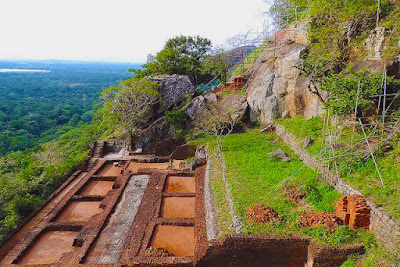
Ø Sigiriya Rock Fortress - Climb the Sigiriya rock fortress and see the beautiful Frescoes, Landscape, Architecture, Construction technology, exceptional hydraulic engineering, Management skills & harmony between humans and nature. All these you can see during the climb of the Sigiriya Rock Fortress. To reach on the top of Sigiriya Rock Fortress: It takes approximately 2 hours and you have to climb 1200 steps to reach on the top. This is the main thing one must have to do in Sigiriya and which is amazingly interesting too.
Ø Pidurangala hike – Pidurangala: Also an ancient Buddhist temple and rock. At the top of the rock, you can see the best shape of the Sigiriya Rock and it’s a picturesque location. Approximately it takes 1 hour to reach the Pidurangala peak.
Ø Minneriya Safari - Minneriya Safari is a very famous wildlife safari for all travellers. During Dry Season, The largest number of Sri Lankan elephants gather to grass fields on the edges of the Minneriya reservoir. Mostly more than 150 elephants gather at once & on some days almost 350 elephants gather at once. This is one of the best places to see the wild elephants in the South Asian region.
Ø Sigiriya Village Tour - This is a lifetime opportunity to be emerged with the nature & culture of the Sri Lankan Village Life. You can have an amazing ride on Bullock cart around the village & boat ride of the lake and walk in the paddy fields & finally, you can enjoy the Sri Lankan Village meals. To explore the entire village, one will take approximately 2 hours & 30 minutes.
Places To See In Sigiriya
· Minneriya National Park Safari
· Pidurangala Rock
· Pidurangala Royal Cave Temple
· Sigiriya Archaeological Museum
· Sigiriya Cobra Hood Cave
· Sigiriya Rock Fortress
· Sigiriya Village


No comments:
Post a Comment